
🧭 Navigate Boldly, Capture Freely, Explore Limitlessly!
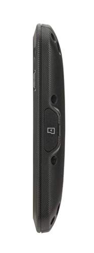
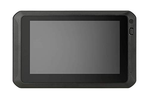
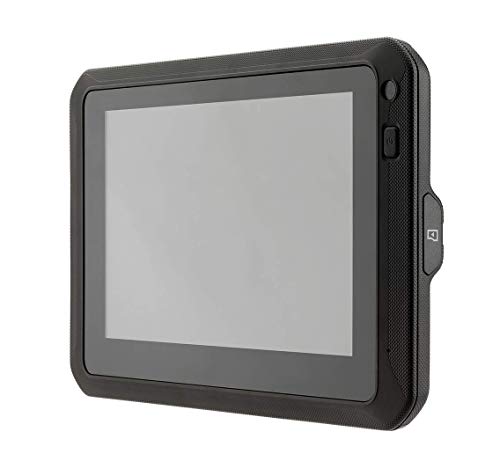
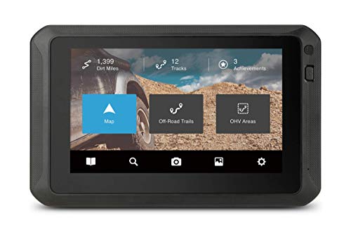
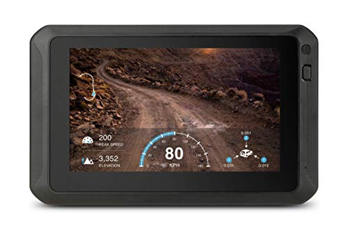
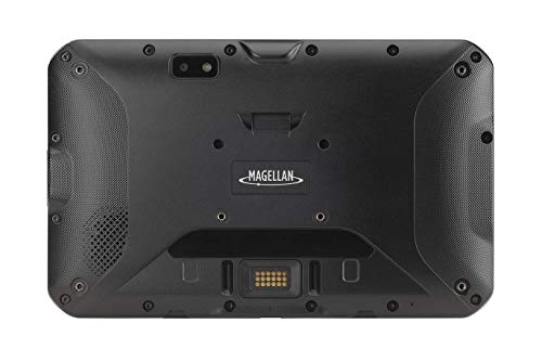
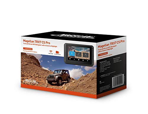
The Magellan TN1840SGLUC TRX7 CS PRO is a 7-inch dual-mount GPS navigator designed for both trail and street use, featuring an 8MP rear-facing camera with LED flash, pre-loaded 2D/3D topo maps of the USA and Canada, and free lifetime map updates. It offers advanced trail searching, track recording, and multiple mounting options, making it a versatile companion for off-road explorers and adventure seekers.
| ASIN | B08QYZZXYF |
| Batteries | 1 Lithium Ion batteries required. (included) |
| Best Sellers Rank | #110,716 in Electronics ( See Top 100 in Electronics ) #108 in Handheld GPS Units |
| Color | Black |
| Connectivity technologies | USB |
| Customer Reviews | 3.5 3.5 out of 5 stars (112) |
| Date First Available | December 18, 2020 |
| Department | Unisex-Adult |
| Human Interface Input | Buttons, Touchscreen |
| Is Discontinued By Manufacturer | No |
| Item Weight | 3.3 pounds |
| Item model number | TN1840SGLUC |
| Manufacturer | MiTAC Digital Technology Corporation |
| Other display features | Wireless |
| Product Dimensions | 8.3 x 5.2 x 0.82 inches |
| Scanner Resolution | 1024 x 600 |
| Special features | Advanced trail searching, plus millions of POIs, Built-in 8.0-megapixel rear-facing camera with LED flash, Instant video playback on device, Off-course notifications and backtrack, TRX Trailhead map database and planning/sharing tools |
| Whats in the box | Magellan TN1840SGLUC TRX7 Offroad Nav |
J**E
Good for trails and exploration
I got this GPS to use in my jeep. I also wanted to replace an old dash cam that's been slowly melting in the sun. It has decent mounting hardware with a window suction cup, motorcycle handlebars or even some screw holes on the back if you wanted to mount it on a plate for a UTV. It comes with a bunch of cables and adapters although most of my tech is micro USB now. It has some decent texture on the sides, so it doesn't slip out of my hands like my phone. The software takes a little getting used to, but is pretty simple. It has a ton of trails already loaded, and I discovered a ton of new trails near me. One of the features I really like is the "make a track" function where you can breadcrumb your drive and set markers for water crossings or scenic spots. This is neat for me cause I'm always finding cool jumps and tracks in the desert and am never able to find my way back to those exact spots.
K**M
Not as good as thought it woul be - Pretty dissapointed
The off road capabilities are good. Forget about using this for street navigation (for that function I give this ONE star). The map details is pretty bad, especially when using street navigation. When you search for an address in the search function for street navigation there is a 75% chance you get back "no results found". It is very handy for off road trails, but when you navigate a trail it pretty much draws a green line and you follow the green line without any map details -super basic!. The android tablet itself which is the operating system is also very sensitive and tricky to navigate. It constantly freezes up and you always have to turn if off and then back on to get it to unfreeze. It is nearly impossible to plan a route or search for anything using the hand held unit because of the freezing up. You pretty much have to do all your mapwork and planning on the companion website which will upload into the handheld unit when it syncs because the tablet is so sensitive to freezing up. I think Magellan made a mistake by using the lowest specification of Android tablet software to run this unit. The OS system in the tablet itself is horrible. The zooming (pinching and spreading the screen) function is horrible, it will not keep the map locked in up North position and the whole screen goes to spinning when you use this function. The social media upload function did not work at all. The first time I tried to enter my Facebook sign in information it gave me an error message stating "app unavailable at this time" I still cannot get rid of that message and the social media option is dead in the water. Also while in navigation heads up mode you cannot use any other functions because every time you try and look at anything else you get a flag notice that says "Do you want to end current navigation?" So one you route has started you just cant touch the unit for any reason for fear of having to end your route navigation. All in all, I wish I had purchased a Garmin or other unit that had both street maps and off road maps. This one is a big disappointment.
P**N
TRX7 CS Pro
This is an good gps unit. Does what it says it will do, but is somewhat difficult to navigate through. For the money I paid (for open box content) it will serve the purpose just fine. I look forward to using it on the HMT trails in April. Tried to find a way to sink it to my phone, but was unsuccessful, so far. Also tried to publish a map of 5313 Offroad Park. Unsuccessful at that too. As long as I can pull up maps of the parks I go to it will be fine. Because the gps works great. Oh! Don't plan on using the street gps on this unit. Not all roads are listed, therefore, addresses cannot be found. I would probably go with a 7-8 out of 10 rating (prbably closer to 7 than 8).
L**O
One of the best purchases for my SxS.
There is a learning curve to any new GPS unit and I hate spending the time to learn how to use this stuff. That said I bit the bullet and sat down a couple of times learning the basic features and it makes the ride way more enjoyable. It’s worth the time to learn saving frustration using these while traveling. I have a ways to go but I enjoy using this more and more as time goes by.
W**E
Overpriced
Map difficult to decipher trail numbered/names. Memory card fills up quickly. When recording and plugged into power, screen goes black and you don’t know if it’s recording or not plus you loose map when recording. Maps not up to date, by a long shot. It’s a tablet with a program that runs on it and you have to hunt for how to access the behind scene to clear memory and other settings.
R**S
I do not recommend this!
Some of my issues might have been repaired if I had the patience to jump through all the hurdles such as spending hours on the phone, if or when you get someone to answer the phone. The camera did not work, the machine crashed several times, and it finally just got stuck on trying to download updates; all of these issues appear to be software related. The real issue that cannot be fixed is that the maps are some of the worst I've ever seen. They have virtually no detail, many county roads do not exist and hardly any geographic items are not named or labeled so you cannot use such items as mountains, rivers or even town names as reference points. I hardly ever send anything back, but this was just too expensive to throw into the reject pile.
L**0
Seems good so far.
Easy setup. Had several locations preloaded close to me. But I like the ability to save my own path with it and the backtracking feature if you get lost!
W**C
Horrible support
I think I will like the GPS. However for some reason my camera would not work. I called Magellan. Gave them a call back number also emailed Magellan. I got crickets. I was going to send it back, but for me it filled all the boxes, however no camera was a big deal. After a couple days of fiddling with it I found a camera force quit button. A warning came up when I decided to try it. I touched it anyway. Well, the camera came up when it rebooted. I really feel alone on this purchase. Magellan was no help whatsoever. I gave it 2 stars not for the GPS aspect, but for the support or lack of support. I will figure it out, but obviously without help from the people that made the thing. I think I am going to buy the add on warranty. I don't trust Magellan at all with this purchase.
Trustpilot
2 months ago
1 month ago