

Desertcart purchases this item on your behalf and handles shipping, customs, and support to South Korea.
๐ฅ๏ธ Float, track, and conquer every wave with confidence!
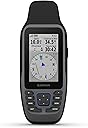
The Garmin GPSMAP 79sc is a rugged, floating marine handheld GPS featuring a sunlight-readable 6-inch color touchscreen, preloaded BlueChart g3 coastal charts, and multi-constellation satellite support for precise global navigation. With IPX6 water resistance, a built-in 3-axis compass, barometric altimeter, and expanded memory for 10,000 waypoints and 250 routes, itโs engineered for serious marine adventurers who demand reliability and durability on every voyage.


| ASIN | B09GX6JSYJ |
| Additional Features | Designed to Float; Increased Memory; Built-in Compass; BlueChart Coverage |
| Audio Output Mode | Digital |
| Battery Average Life | 20 hours |
| Best Sellers Rank | #21,555 in Electronics ( See Top 100 in Electronics ) #16 in Handheld GPS Units #1,686 in Boating Equipment |
| Brand | Garmin |
| Built-In Media | GPSMAP 79sc; Lanyard; USB cable; Documentation |
| Compatible Devices | Smartphone, Tablet |
| Compatible with Vehicle Type | Boat |
| Connectivity Technology | USB |
| Control Method | Touch |
| Customer Reviews | 4.0 out of 5 stars 181 Reviews |
| Display Type | LED |
| Human-Interface Input | Touchscreen |
| Item Dimensions L x W x H | 2.6"L x 1.2"W x 6"H |
| Item Type Name | Marine GPS |
| Item Weight | 282 g |
| Manufacturer | Garmin |
| Map Types | North America |
| Memory Storage Capacity | 8 GB |
| Mfr Part Number | 010-02635-02 |
| Model Name | GPSMAP 79sc |
| Model Number | 010-02635-02 |
| Model Year | 2022 |
| Mounting Type | Wrist Mount, found in image |
| Number of Items | 1 |
| Number of Packs | 1 |
| Operating System | Windows |
| Resolution | 240 x 400 |
| Screen Size | 6 inches |
| Software Update Supported to Date | unknown |
| Special Feature | Designed to Float; Increased Memory; Built-in Compass; BlueChart Coverage |
| Sport Type | Fishing |
| Supported Satellite Navigation System | GPS |
| Touch Screen Type | Capacitive |
| UPC | 753759284534 |
| Unit Count | 1 Count |
| Vehicle Service Type | Boat |
| Warranty Description | 1 year limited warranty |
B**N
NMEA output Capable
Garmin has never been good at describing features or how to use them on their GPS systems. It is certainly the case for this very capable handheld GPS device. One must learn by scrolling through the menus and getting your device to do what you want it to. I got this Garmin GPSMAP 79sc to replace my 76Cx which, after years of using, had a simple battery compartment issue I was unable to fix. I had set up and used my old Garmin to, among other things, communicate NMEA streams of data to my autopilot on my sailboat. I shopped online, even at the official Garmin site, and looked for this feature among GPS handhelds with no luck. I even went into a retail store to talk with knowledgeable salespeople as to what product would do this. No luck. But while having the 79sc in my hand, I noticed it had the Garmin round plug port for power and I/O which wasnโt even mentioned or shown in online descriptions. The Quick Start booklet which came in the box said nothing about the port, and the ownerโs manual, which I had to download, had little. I took a chance and bought it. Turns out I could get this working like my old device by exploring the menus. Not much help from any written direction provided by Garmin. It must be a legacy feature not used by many today. The 79sc has many features, some useful to me and some not, but it is very capable. It determines position faster than my old, almost instantaneously. The compass feature is handy and works by some technology alien to me. Probably magic. And the unit I got, being preloaded with coastal charts, is nice. Display is nice. The scrolling buttons are a bit touchy. Iโll wait to test out its waterproof and floating capabilities until I accidentally drop it overboard. So, if you want a very capable handheld GPS, try the Garmin GPSMAP 79sc. Just be patient, explore the device, and get to know each other together.
H**M
Quick ship - โFreshโ unit
Unit had the latest software loads including system software and BlueChart loads. Very quick delivery. Nice! This was purchased as a backup unit for one bought a year ago. Still learning how to use the routing and recording features. It has not been completely intuitive but the manual full download helps. Accuracy & startup time are excellent. Predicted battery life of 19 hours seems accurate but wish it was 24 hoursโฆ. A very solid unit.
W**C
Excellent service
Prompt efficient service. Excellent product. Shipping seamlessly delivered on time
C**.
Prefer Navionics maps on phone better.
Multiple reasons I donโt like this unit. Doesnโt hold micro as card well, falls out. Canโt load and use inland charts and use preloaded coastal charts together, have to toggle between the two. Not a huge problem unless entering a river from bay, soundโฆ Donโt like the chart, prefer Navionics charts better. I knew it had a small non touch screen before purchasing, but really displeased with not having.
J**G
Be careful, have money for new maps and a LOT of patience.
Be very cautious when you buy this unit. 1. It will likely come with the old 2024 or 2023 map. An upgrade will cost you $100, per chart (inland and coastal). 2. If you live in a coastal area near the Intercostal Waterway and have any inland rivers that connect to it - these are 2 separate charts. Each will be $100 to upgrade. 3. Even if you do upgrade, you have to install a micro-SD card in the unit. The micro SD card is held down by a tiny piece of metal which can come loose and fall out of your hands, potentially being lost. Switching between costal and inland maps, which we do here in Jacksonville, will mean you have to take the unit apart, on the boat, and swap SD cards. Try not losing that little metal clip. 4. Customer service ranges from pretty good to terrible at Garmin. I just had a guy chew me out because I didn't want to have to fumble around swapping out SD cards in a terribly designed, easy to lose/damage area on the unit, while driving the boat! And, that's in a wet environment, you have to open the back of the unit, take out batteries and fiddle with that little clip - which I'm sure is not waterproof. Not sure how realistic that is, brother. 5. Screen is very hard to read in the sun - very hard. 6. Menu system is a mess - unit comes configured for hiking??, but no topographical maps, just marine charts. You have to change multiple settings for marine navigation. if you have an IT degree and a lot of patience to learn the terrible menu system, this unit has a purpose and might be a good backup. But, if you want something easy to use, that will get you from the ICW to connecting rivers without disassembling it each time you cross, and has updated maps that you pay $100 each time you upgrade, this might be a good unit for you.
J**S
Marine set-up not for the technically challenged
I had to ask the gps sales person at Hamilton Marine to set up the charts for marine operation. It is not easy. However, since then, I have been able to use and enjoy the features of this gps. I use it planning and tracking multiple weekly ocean kayak trips of 6-15 nautical miles and 2-5 hours. The map does not label smaller islands which is a problem so I always have a paper chart with me. What is excellent is that I can read the screen, mounted on the deck, in all light conditions. Lithium batteries provide me about 15 hours of tracking with this gps. The GPS is exposed to weather and salt as I have it on a Garmin portable mount on the deck of my kayak so I rinse it under the faucet after each trip. After 2 years of use - May through November - it still looks new and has never leaked. I am very happy with this gps.
E**H
Good hand held GPS
I didnโt like the Garmin 79sc because it would not allow staying on longer than 2 minutes so I sent the Garmin and ram mount back. I got my old 478 working again with a new antenna and again have a chart plotter on a ram mount that stays on. The need to wake up the 79sc every 2 minutes or less was the only issue. I understand the reason is the preserve the battery charge since there is no option to plug into the 12 volt boat power. The functionality of the 79 sc would be great for a portable gps that you could power up quickly and perform numerous functions, and then turn off. For any activity that allows you to slow up or stop to use the gps Iโd recommend this unit. For a chart plotter on a boat without a second person to operate this unit, itโs too inconvenient to slow to idle to check your position and depth especially if you operate in shoal water. I got lucky that a new antenna revived my discontinued Garmin 478. I will rinse the salt water off the unit and detachable antenna connection every time now.
J**O
like new
nice product well packed
M**N
Gps
This product is awso.e and does everything I need it to
G**G
Fantastico
Lo que esperaba
B**T
Not as described.
I could have or should have bought a cheaper version with all the same features. It didnโt come with the BlueChart maps loaded as advertised.
G**.
Excelente GPS marino, debes dedicarle tiempo para manejarlo bien Muy recomendable
4**4
Do not buy for the maps
I purchased this to use for ice fishing. Paid the extra believing the included maps but they are only for coastal waters you need to spend another 130.00 to get CND maps I returned this and am considering the S model than add in the map. Took forever to get a refund
Trustpilot
1 month ago
2 months ago