
Desertcart purchases this item on your behalf and handles shipping, customs, and support to South Korea.
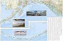
โข Waterproof โข Tear-Resistant โข Travel Map Alaska is a land so vast that is boggles the imagination. It is so large that it could easily contain the next three largest states: Texas, California, and Montana and still have room left over. Despite its large size Alaska has very few inhabitants making it the state with the lowest population density. Alaska is known for its dramatic, diverse terrain of wide-open spaces, mountains and forests, with abundant wildlife and many small towns. A majority of Alaska, sixty percent, is owned and managed by the Federal Government. These lands are open to the public and offer a wide range of activities from sightseeing in Denali National Park to river-running and fishing on one of many wild rivers. Many vistors to Alaska choose to arrive via cruise ship through the famous Inside Passage. The Alaska Adventure Map shows all of these features and more from the temperate rain forest in the Pan Handle to the arctic tundra of the North Slope. This is a state of diverse and wide open spaces that are still truly wild. Alaska's most famous hotspots, like Denali, Anchorage, the Inside Passage, Klondike Gold Rush National Historical Park, and many others are clearly marked on the map. The boundaries of National Parks, National Forests, Natural Reserves and Wildlife Refuges are all clearly marked. With such a wealth of content, the map is an ideal complement to National Geographic's Inside Passage Destination Map or any other guidebook to the area. Every Adventure Map is printed on durable synthetic paper, making them waterproof, tear-resistant and tough โ capable of withstanding the rigors of international travel. Map Scale = 1:2,250,000 Sheet Size = 25.5" x 37.75" Folded Size = 4.25" x 9.25" Review: Recommended - Great map. Very detailed. It will be very valuable for our road trip. Review: Maps really aid travel. We flew to Australia on "The Great Circle" route to Hong Kong by Alaska - I would like to go to the mainland of Alaska and see for real what I've seen only on TV and in the air at 20,000 ft.. Although we have flown over the Allusion Islands of Alaska on our way to Australia via Hong Kong. I got to see Attu Island at the western end of the Allusion Islands. We saw Eastern Russia and China on the way and flew over Taiwan before landing in Hong Kong. On our way back I saw the sunrise before it rose on the western US. 20,000 feet altitude lets you see around the curvature of the Earth quite a bit.


| Best Sellers Rank | #37,649 in Books ( See Top 100 in Books ) #33 in Pacific West United States Travel Books #54 in United States Atlases & Maps (Books) #72 in Maps (Books) |
| Customer Reviews | 4.8 out of 5 stars 553 Reviews |
T**E
Recommended
Great map. Very detailed. It will be very valuable for our road trip.
F**R
Maps really aid travel. We flew to Australia on "The Great Circle" route to Hong Kong by Alaska
I would like to go to the mainland of Alaska and see for real what I've seen only on TV and in the air at 20,000 ft.. Although we have flown over the Allusion Islands of Alaska on our way to Australia via Hong Kong. I got to see Attu Island at the western end of the Allusion Islands. We saw Eastern Russia and China on the way and flew over Taiwan before landing in Hong Kong. On our way back I saw the sunrise before it rose on the western US. 20,000 feet altitude lets you see around the curvature of the Earth quite a bit.
C**5
Great value and price
Very nice maps for sure!
M**E
Very nice map
Heading out next year for an epic Alaska trip so I thought I'd get a map. As most people say the quality is not a paper map you get at a rest stop, it's vinyl coated or some sort of coating so it resists creasing and tearing. The map itself has a lot of attraction on it in the way of parks, SRA, state parks, national parks and terrain. The print is a bit small but very readable. If you want a quality map that doesn't end up with holes in the folds, this is the map for you.
J**S
Not a street map
Trying to find a street map for a road-trip around Fairbanks. Based on other reviews I assumed it would have all of the roads but it really just shows the highways and is so small would be hard to navigate during the road trip. Will keep searching but wanted to warn others in case you are looking for the same. Nice map of the state, cities, parks etc just not what I need.
B**T
A quality map
This is our first National Geographic map. I love the glossy sheen! It appears to be well-made, readable, and detailed. We plan to use it as a driving guide in Alaska, so the fact that the map is two-sided isn't a detriment. It's big enough to contain lots of detail, but not so big that it's cumbersome. It's heavier than other maps of its size, which speaks to its quality. Once we've actually used the map on the road, I can come back and update this review if I have additional observations.
P**R
Great maps.
Trails Illustrated always prepares a great product. The maps are clear and of course water resistant. I would suggest that the boundary lines around the national parks could be darkened somewhat. They fade a little into the background. But thanks for so many great maps over the years.
M**W
Resource for Alaskan Travel
We set up an itinerary through an Anchorage travel agency for our 40th anniversary. The map help us through the 2,400 mile trek through the main part of the state that itinerary took us. The map has helped post trip to allow us to "geo tag" photos. The usual high quality National Geographic product.
A**A
Qualitรฉ top
Ne se dรฉchire pas, ne s'abรฎme pas sous la pluie, top, je recommande
A**A
Well protected map thatโs easy to use
Excellent, well protected map against the weather or tearing. Full of detail and easy to use.
C**N
Valido
Come.da annuncio
O**I
Quality of the map - in material, detail and durability.
Using this for adventure planning. An opportunity for improvement comment: I am used to maps that you flip side-to-side versus top-to-bottom; especially when the location index / reference is on the opposite side of the major portion of the map. It would be much easier & faster to utilize the index / reference if this map could be flipped side-to-side. thank you
A**R
Very good map. I like all National Geographic
Very good map. I like all National Geographic publication
Trustpilot
1 month ago
2 weeks ago